《山海經 053(現代視角)》《山海經》中的世界地圖,真的存在嗎? Could the World of Shan Hai Jing Be Real?
《山海經》描繪的山川與異域似真似幻,既像地圖又似神話。它是否反映真實世界,還是純粹想像,一直是後人探討的謎題。
The landscapes in the Shan Hai Jing blur the line between geography and myth. Whether they reflect real places or imaginative visions remains an enduring question.
中文
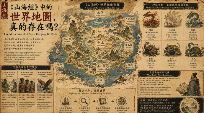
在遠古時代,人們尚未擁有精確的地圖,世界的輪廓存在於傳說與口耳相傳之中。《山海經》便誕生於這樣的背景,它記錄了無數山川、河流與異域之地,彷彿一幅古老的世界地圖。然而,這幅地圖並非以比例與經緯構成,而是由故事與想像交織而成。有人說,那些山脈可能對應真實存在的地理位置,那些河流或許源自實際的水系,但在漫長的傳播過程中,它們逐漸被神話化,融入了怪物與神祇的描述。於是,一個原本可能真實的世界,被重新塑造成充滿奇異與神秘的圖景。旅行者的見聞是這幅地圖的重要來源。當古人踏上未知之地,所見所聞往往零碎而難以理解。他們將觀察到的景象帶回故土,經過口述與記錄,逐漸形成故事。然而這些故事在傳播中被不斷放大與改寫,最終變成我們今天所看到的《山海經》。某些動物被誇張為神獸,某些地形被賦予神秘力量,甚至連遠方民族的特徵也被轉化為奇異的形象。這種轉化使地圖不再只是空間的描述,而成為文化與想像的載體。另一方面,《山海經》也可能反映了一種象徵性的地圖。它並不試圖精確描繪世界,而是以空間來表達觀念。不同的山川代表不同的力量,不同的地域象徵不同的秩序與混亂。世界被分為中心與邊緣,文明與未知在其中交錯。那些遙遠而怪異的地方,既是現實世界的延伸,也是人類心中對未知的投射。因此,《山海經》的地圖既真實又虛幻。它可能包含某些真實地理的痕跡,但更重要的是,它呈現了古人如何理解世界。在沒有科學測量的時代,地圖不只是工具,更是一種敘事方式。它將經驗、想像與信仰融合在一起,構建出一個可以被理解的宇宙。當我們今天重新閱讀這部作品,不應只問它是否真實存在,而應思考它如何描繪真實。那些山與海、那些奇異的生物與民族,都是古人認識世界的方式。它們不一定對應具體的地點,卻真實地反映了一種思想與文化。於是,《山海經》的世界地圖或許從未以我們所理解的方式存在,但它卻以另一種形式存在於歷史與想像之中,成為連結現實與神話的橋樑。
English Version
In an age before precise cartography, the shape of the world was not fixed by coordinates or measurements but by stories and shared imagination. The Shan Hai Jing emerged from such a context, presenting what appears to be a map of mountains, rivers, and distant lands. Yet this “map” does not follow the logic of modern geography. Instead, it is constructed through narrative, where space is defined as much by meaning as by location. Some scholars suggest that certain descriptions may correspond to real places—mountain ranges, waterways, or regions encountered by early travelers. However, as these accounts were passed down through generations, they became layered with interpretation, exaggeration, and myth. What may have begun as observation gradually transformed into something richer and more symbolic. Travelers played a crucial role in shaping this world. Their journeys brought back fragments of unfamiliar landscapes and cultures, often described through limited understanding. These fragments, retold and reshaped, evolved into vivid depictions filled with extraordinary creatures and strange customs. A distant animal might become a legendary beast, while a foreign community might be reimagined as something uncanny or otherworldly. In this way, the Shan Hai Jing is not simply inaccurate—it is expressive. It captures how people processed new information, blending reality with imagination to create coherence. At the same time, the text can be seen as a symbolic map. Rather than aiming for geographic precision, it organizes the world according to meaning and relationship. Certain regions represent order, others chaos; some embody familiarity, while others stand for the unknown. The boundaries within this map are not merely physical but conceptual, reflecting how early societies distinguished between what they understood and what they feared. This dual nature makes the Shan Hai Jing both real and unreal. It may contain traces of actual geography, yet its true significance lies in how it represents the world. In a time without scientific mapping, a “map” was also a story—a way to interpret existence. It connected observation, belief, and imagination into a unified vision of reality. Today, asking whether this world truly existed may miss the deeper point. The landscapes of the Shan Hai Jing exist not only in physical space but in cultural memory. They reveal how people once perceived their surroundings, how they transformed uncertainty into narrative, and how they constructed a world that felt meaningful even without precise knowledge. In that sense, the map of the Shan Hai Jing may not exist in the way we expect, but it remains profoundly real as a reflection of human thought and imagination.