《山海經 054(現代視角)》山海經與現代地理的對照:神話與現實的交界 Mapping Shan Hai Jing to Modern Geography: Where Myth Meets Reality
《山海經》記錄的山川與地域,是否能對應現代地理?在神話與現實之間,隱藏著古人觀察世界的痕跡與想像。
Can the landscapes described in the Shan Hai Jing be linked to modern geography? Between myth and reality lies a fascinating record of how ancient people perceived the world.
中文
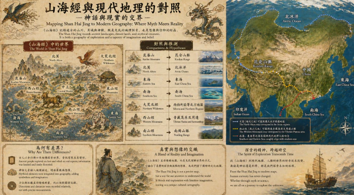
在沒有衛星與測繪技術的年代,人類對世界的理解來自腳步與傳聞。《山海經》正是在這樣的背景下誕生,它記錄了數以百計的山脈、河流與異域之地,彷彿一幅早期的地理圖譜。然而,當現代學者試圖將這些描述與現實世界對照時,卻發現這並非一項簡單的工作。有些山川的名稱與位置似乎能與中國境內的地理特徵相呼應,例如某些山系可能對應秦嶺或崑崙山的概念,而某些水域描述也與古代河流系統相似。但這種對應往往模糊而不確定,因為《山海經》的記錄並非依照精確距離與方向,而是以敘事方式排列。旅行者的經驗在其中扮演關鍵角色。他們的行程可能跨越不同地區,但在記錄與傳播的過程中,這些片段被重新組合,形成一種連續卻不完全準確的空間結構。於是,一條河流可能被延伸或縮短,一座山可能被重複或移動。這種變形使得地圖更像故事,而非精確的測繪。同時,《山海經》中的地理並不僅僅是物理空間,它還承載著文化與象徵。某些地區被描述為充滿神獸或異族,這可能反映了古人對邊疆與未知世界的想像。當現代讀者試圖將這些地點與具體位置對應時,往往忽略了它們的象徵性意義。這些地方或許並不指向某個確切的地點,而是代表一種「遠方」或「他者」。然而,這並不意味著《山海經》完全脫離現實。相反,它可能是一種混合體,結合了真實地理與想像元素。某些記錄可能源於真實的旅行經驗,而另一些則來自傳說與推測。這種混合使得它既難以驗證,又充滿魅力。現代科技讓我們能夠精確地描繪世界,但也讓我們重新思考古人的地圖觀。《山海經》並非失敗的地理學,而是另一種理解空間的方式。它將經驗、記憶與想像融合在一起,構建出一個有意義的世界。當我們試圖將它與現代地理對照時,不只是尋找對應關係,更是在理解兩種不同的世界觀。一個追求精確與測量,另一個則重視敘事與象徵。這種差異提醒我們,地圖不只是工具,也是一種文化表達。於是,《山海經》與現代地理之間的對照,不是一場簡單的比對,而是一段跨越時間的對話。在這場對話中,我們看見的不只是山與河,更是人類如何理解世界的不同方式。
English Version
Before the development of precise mapping technologies, knowledge of the world was shaped by journeys, memory, and storytelling. The Shan Hai Jing emerged from this context, offering what appears to be a catalog of mountains, rivers, and distant regions. Yet when modern scholars attempt to align these descriptions with contemporary geography, the process proves complex and often inconclusive. Certain features described in the text seem to echo real landscapes. Some mountain ranges may correspond loosely to known regions such as the Qinling or Kunlun ranges, while certain waterways resemble ancient river systems. However, these connections are rarely exact. The text does not organize space through measurable distance or consistent direction. Instead, it follows a narrative logic, where places are linked through stories rather than coordinates. Travel accounts likely played a significant role in shaping these descriptions. Early explorers gathered fragments of knowledge from different regions, but as these fragments were recorded and retold, they were rearranged into a continuous yet imprecise spatial structure. A river might be extended beyond its actual length, a mountain duplicated or relocated, creating a geography that feels coherent but resists precise mapping. At the same time, the landscapes in the Shan Hai Jing are not purely physical—they are also symbolic. Certain regions are associated with strange creatures or unusual peoples, reflecting perceptions of distant and unfamiliar territories. These places may not correspond to specific locations on a modern map, but instead represent conceptual boundaries between the known and the unknown. Attempting to identify them solely through geographic comparison risks overlooking their deeper meaning. Nevertheless, the text is not entirely detached from reality. It can be understood as a hybrid of observation and imagination. Some elements may derive from genuine encounters with real environments, while others emerge from interpretation, exaggeration, or mythmaking. This blending gives the Shan Hai Jing its enduring fascination. Modern mapping allows us to define the world with precision, but it also highlights the uniqueness of earlier approaches to space. The Shan Hai Jing is not a flawed version of geography; it is an alternative way of organizing knowledge. It integrates experience, memory, and symbolism into a meaningful representation of the world. Comparing it with modern geography, therefore, is not simply about finding matches, but about understanding two different ways of seeing. One prioritizes accuracy and measurement, the other meaning and narrative. In this comparison, we gain insight not only into ancient landscapes, but into the evolving human effort to make sense of the world itself.