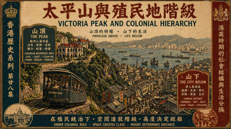
十九世紀香港迅速發展,太平山逐漸成為殖民權力與社會階級的象徵,山頂與山下形成明顯分隔,反映出殖民地制度下的空間與身份差異。
As Hong Kong evolved in the nineteenth century, Victoria Peak emerged as a symbol of privilege, where elevation mirrored status and spatial divisions reflected deeper social hierarchies shaped by colonial rule.
中文
太平山在早期香港不僅是一個地理高地,更是一個象徵權力與階級的空間標誌,自香港開埠以來,英國殖民者逐步將山頂發展為專屬居住區,利用其涼爽氣候與遠離市區的環境優勢,打造出與山下截然不同的生活空間,在十九世紀中後期,隨著城市人口增加與衛生問題加劇,殖民政府開始強調山頂作為歐洲人居住區的重要性,並逐步制定限制措施,實際上將華人排除於山頂之外,這種以地理高度劃分族群的制度,使太平山成為殖民階級制度最具象徵性的場所之一,山頂的建築以寬敞洋房與花園為主,空氣清新、景觀開闊,與山下擁擠的華人社區形成強烈對比,而山下的中環與上環則聚集大量華人勞動人口與商業活動,街道狹窄、人口密集,生活條件相對艱難,這種上下分隔的空間結構,不僅反映經濟差異,更體現殖民統治下的種族與社會階層制度,太平山的發展亦與基礎設施建設密切相關,纜車系統的興建大大改善了交通,使殖民精英能夠輕鬆往返山頂與市區,進一步鞏固其居住優勢,而這些設施在當時主要服務於歐洲居民,華人難以享有同等資源,隨著時間推移,一部分華人富商逐漸崛起,開始挑戰這種空間限制,他們透過經濟實力爭取居住權,逐步打破山頂的種族隔離,但這一過程並非一蹴而就,而是伴隨著制度鬆動與社會變遷逐步實現,太平山亦成為殖民權力象徵的展示場,從山頂俯瞰整個維多利亞港與城市景觀,彷彿掌握整個殖民地的運作,這種視覺與空間的優勢進一步強化了權力結構的象徵意義,同時山頂亦是文化與生活方式差異的集中體現,歐洲式生活、社交活動與建築風格在此發展,而華人社區則在山下延續傳統文化與商業活動,形成兩種並存但分隔的城市節奏,然而隨著二十世紀初的社會變化與經濟發展,這種嚴格的空間與階級界線逐漸鬆動,華人精英的崛起與教育普及改變了社會結構,使太平山不再是單一族群的象徵,而成為多元社會的一部分,回顧早期香港歷史,太平山的存在不僅揭示殖民地社會的分層與不平等,也見證了香港由分隔走向融合的過程,從一個象徵排他與權力的高地,逐漸轉變為共享城市景觀的重要地標,這段歷史反映出空間如何被權力塑造,同時也顯示社會如何在變遷中重新定義自身的結構與身份
English Version
Victoria Peak in early Hong Kong was far more than a scenic hill, it represented a spatial expression of power and hierarchy within the colonial system, from the early years of British rule, the Peak was gradually developed into an exclusive residential enclave reserved primarily for Europeans, valued for its cooler climate, cleaner air, and distance from the crowded and often unsanitary conditions of the lower city, as Hong Kong’s population expanded and public health concerns intensified during the nineteenth century, colonial authorities reinforced the importance of the Peak as a privileged zone, introducing regulations that effectively restricted Chinese residents from living there, creating a stark division where altitude became a marker of status and race, the architecture of the Peak reflected this exclusivity, with spacious villas, landscaped gardens, and panoramic views overlooking Victoria Harbour, offering a lifestyle that contrasted sharply with the dense and bustling Chinese districts below, in Central and Sheung Wan, where narrow streets, vibrant markets, and tightly packed housing defined everyday life, this vertical separation was not merely geographic but deeply social, embedding inequality into the very layout of the city, infrastructure developments such as the construction of the Peak Tram further reinforced this divide, providing convenient access for the colonial elite while remaining largely inaccessible to ordinary Chinese residents, over time, however, the rigid boundaries began to shift as a growing class of wealthy Chinese merchants accumulated influence and sought entry into spaces previously denied to them, their efforts gradually challenged the exclusivity of the Peak, reflecting broader social changes within Hong Kong, the hill also carried symbolic meaning, from its elevated vantage point, colonial authorities could quite literally look down upon the city, reinforcing a sense of control and dominance, while the cultural life of the Peak developed along European lines, the communities below maintained Chinese traditions, resulting in a dual urban identity that coexisted yet remained divided, by the early twentieth century, economic growth, education, and social mobility began to erode the strict segregation that once defined the Peak, transforming it from a symbol of exclusion into a more integrated part of the city, the history of Victoria Peak thus reveals how space can be shaped by power while also evolving through social change, illustrating Hong Kong’s journey from a divided colonial outpost to a more complex and interconnected society