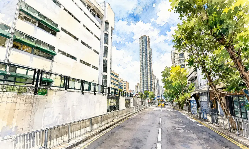
街道筆錄 | 鳳攸南街|從雞地農墟到元朗深夜食街的城市變奏 Fung Yau Street South | From Poultry Market Grounds to Yuen Long’s Late-Night Food Street
中文:在今日燈火通明、人聲鼎沸的元朗美食地帶之中,鳳攸南街看似只是平凡街道,但它的名字背後,其實藏著雞地農墟、原居民村落與新市鎮發展交織而成的地方故事。
English: Beneath the busy restaurants and glowing shopfronts of modern Yuen Long lies the memory of an older landscape shaped by poultry traders, village fields, and colonial-era urban planning. Fung Yau Street South quietly preserves that forgotten transformation within its very name.
中文
鳳攸南街位於元朗市中心南部,是今日區內著名的民生飲食街之一。每到傍晚,街道兩旁便陸續亮起火鍋店、雞煲店、泰越餐廳與兩餸飯店的霓虹燈牌,人流熙來攘往,形成一種獨特的新界夜市氣氛。然而許多年輕一代未必知道,這條如今充滿煙火氣息的街道,其實與元朗昔日著名的「雞地」歷史有著極深淵源。1960年代以前,現時鳳攸南街與鳳琴街一帶仍屬元朗外圍鄉郊地區,附近遍布農田、水塘與原居民村落,包括歷史悠久的攸田村。由於位置接近鄉郊交通要道,加上空地廣闊,新界各村的雞農與家禽商販逐漸聚集於此搭建棚屋,形成大型家禽交易市場。每逢墟期,雞、鴨、鵝籠堆滿街頭,叫賣聲與禽鳥聲此起彼落,因此街坊便將該區俗稱為「雞地」。這個帶有濃厚草根色彩的名字,在元朗老一輩居民心中一直具有特殊地位。到了1970年代後期,港英政府正式展開元朗新市鎮發展計劃,大規模收回農地及棚戶區,將元朗由傳統鄉郊市集轉型為現代衛星城市。當局在規劃道路與住宅區時,並未完全放棄地方歷史痕跡,而是透過街道命名保留「雞地」的文化記憶。由於粵語文化中經常以「鳳」作為「雞」的雅稱,例如「鳳爪」其實就是雞腳,因此政府決定以「鳳」字作為整個發展區街道名稱的統一字頭,既保留歷史聯想,同時又令名稱更文雅吉祥。其後區內陸續出現鳳琴街、鳳翔路、鳳群街、鳳香街及鳳攸系列街道,形成元朗其中一個最具代表性的命名系統。而「鳳攸南街」之中的「攸」字,則與附近歷史悠久的攸田村有直接關係。攸田村包括上攸田村及下攸田村,是元朗原居民聚居地之一,早於新市鎮發展前已存在多年。「攸」字除了標示地理來源外,本身亦帶有悠然、長遠與閒適的寓意,因此當「鳳」與「攸」結合後,便形成一種既有地方性、又帶有吉祥文化意味的名稱。這種命名方式非常典型地反映香港殖民地年代城市規劃的特色——在現代化建設之中,適度保留地方文化與原居民痕跡。至於「南」字則屬純粹的地理劃分。隨著1980年代大量私人住宅屋苑落成,包括好順景大廈、好順利大廈等住宅群,政府將「鳳攸」一帶規劃成多條平行街道,並按方位命名為鳳攸北街、鳳攸東街與鳳攸南街。其中鳳攸南街最靠近攸田村及元朗公路方向,因此得名。這種簡潔直接的命名方式,在香港新市鎮規劃中十分常見,同時亦方便居民辨認地區方位。踏入1990年代後,鳳攸南街逐漸由住宅配套街道轉型為區內重要飲食集中地。由於鄰近大量住宅屋苑與交通幹道,加上租金相對元朗大馬路一帶較低,許多特色食肆開始進駐。由最初的茶餐廳與火鍋店,逐步發展成今日匯聚雞煲、泰菜、越南菜、台式料理及深夜宵夜文化的熱門搵食區。尤其夜晚時分,街道瀰漫著火鍋湯底香氣與炒鑊聲,配合密集霓虹燈牌與人潮,形成與傳統市中心截然不同的生活氛圍。這種由農墟演變成飲食街的過程,其實正好反映元朗過去半世紀的城市變遷。昔日的雞鴨棚販與農田雖然早已消失,但街道名稱仍悄悄保留著「雞地」時代的歷史線索。鳳攸南街因此不只是一條普通街道,它更像是一段隱藏在城市霓虹背後的地方記憶,見證元朗如何由新界農村一步步成長為今日繁華而充滿煙火氣的現代社區。
English Version
Fung Yau Street South is now recognized as one of Yuen Long’s busiest food streets, especially after sunset when the area becomes filled with glowing restaurant signs, steaming hotpot shops, late-night diners, and crowds searching for supper. Yet beneath this modern urban energy lies a surprisingly rural past connected to one of old Yuen Long’s best-known local trading grounds — the former poultry market district called “Kai Dei.” Long before residential towers and shopping arcades appeared, the southern section of present-day Yuen Long remained largely agricultural throughout the mid-20th century. Fields, fish ponds, temporary sheds, and indigenous villages shaped the landscape, including the long-established villages of Sheung Yau Tin Tsuen and Ha Yau Tin Tsuen nearby. During the 1950s and 1960s, poultry farmers and traders from surrounding villages began gathering around the area to sell chickens, ducks, geese, and other livestock in open-air markets. Wooden stalls and metal-roofed sheds quickly expanded into a busy informal trading zone. The constant sounds of birds, merchants, and market crowds gave the area its local nickname, “Kai Dei,” or “Chicken Market Grounds.” For older Yuen Long residents, the name became inseparable from the district’s identity. Everything began changing in the late 1970s when the colonial government initiated the Yuen Long New Town development program. Vast stretches of agricultural land and temporary market structures were cleared to accommodate roads, residential complexes, and public facilities as part of Hong Kong’s suburban expansion strategy. Instead of erasing the memory of Kai Dei completely, planners chose to preserve fragments of local culture through street naming. The character “鳳” — meaning phoenix — was selected as a refined substitute for “雞,” or chicken, following traditional Cantonese linguistic customs where poultry-related references are often given more elegant alternative expressions. This decision created a distinctive naming system across the district, resulting in streets such as Fung Kam Street, Fung Cheung Road, Fung Kwan Street, Fung Heung Street, and the Fung Yau series. The second part of the name, “Yau,” was directly borrowed from Yau Tin Tsuen, the nearby indigenous village settlement. Beyond its geographic reference, the Chinese character itself carries meanings associated with calmness, continuity, and ease, giving the overall street name a softer and more poetic tone. The final character, “South,” was introduced simply as part of the area’s directional planning system. As new residential estates such as Ho Shun King Building and Ho Shun Lee Building emerged during the 1980s, the government divided the district into parallel streets identified by compass directions, creating Fung Yau Street North, Fung Yau Street East, and Fung Yau Street South. Among them, Fung Yau Street South occupied the section closest to Yau Tin Tsuen and the Yuen Long Highway corridor. During the 1990s and early 2000s, the street gradually evolved beyond its residential support role and became one of Yuen Long’s most recognizable dining destinations. Compared with the more commercialized Yuen Long Main Road area, rents here remained relatively affordable, attracting a wide range of local eateries and specialty restaurants. Hotpot chains, chicken pot restaurants, Thai cafés, Vietnamese noodle shops, Taiwanese snack stores, and late-night comfort food businesses transformed the atmosphere of the district. Today, the street is especially lively during evening hours, when food aromas, glowing signs, and dense pedestrian traffic create an unmistakable urban energy unique to Yuen Long. This transformation from livestock market to food culture hotspot reflects the broader story of Yuen Long itself — a district that evolved from rural farmland into a densely populated suburban community while still carrying traces of its earlier identity. Although the poultry sheds and muddy trading grounds have disappeared, the memory of Kai Dei continues to survive quietly through names like Fung Yau Street South, reminding the city that even ordinary streets can preserve the hidden layers of Hong Kong’s local history.