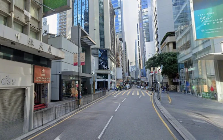
在香港島中環繁忙的城市核心,有一條幾乎與香港歷史同樣悠久的道路——皇后大道中。這條街道由上環一直延伸至中環,是香港最早開闢的主要道路之一,也是維多利亞城最早形成的城市軸線。今天的皇后大道中兩旁高樓林立,銀行總部、金融機構與商業大廈聚集,是香港國際金融中心的重要象徵。然而在十九世紀中葉,這條街只是香港島北岸的一條沿海道路。
若追溯歷史,皇后大道中幾乎可以說是香港城市發展的起點。1841年英國佔領香港島後,殖民政府開始在港島北岸建立維多利亞城。當時的海岸線仍然靠近山腳,因此城市最早的街道多沿海而建。皇后大道正是在這樣的地理條件下出現。最初這條道路被稱為「Queen’s Road」,是殖民政府為紀念英國維多利亞女王而命名。道路沿著海岸線延伸,連接港口、軍營與行政建築,是維多利亞城最重要的交通通道之一。隨著城市逐漸擴展,皇后大道也被分為不同路段,例如皇后大道中、皇后大道西與皇后大道東,其中皇后大道中成為商業與金融活動最集中的一段。十九世紀後期,香港港口經濟迅速發展,維多利亞港逐漸成為亞洲最重要的轉口港之一。大量商船與貨物在香港集散,銀行、洋行與保險公司紛紛在中環設立總部。皇后大道中因此逐漸成為香港最重要的商業街道。街道兩旁出現各式商舖與辦公樓,包括銀行、珠寶店、布匹店與進出口公司。這種繁忙景象使皇后大道中在當時被稱為香港最重要的商業街之一。隨著城市發展,香港政府在十九世紀末至二十世紀初進行多次填海工程。海岸線逐漸向北推移,新的海旁道路如德輔道出現,而原本靠海的皇后大道則變成內陸街道。然而即使海岸線改變,皇后大道中仍然保持其商業核心地位。到了二十世紀中葉,香港經濟開始由貿易港口轉型為金融與服務業中心,中環逐漸成為銀行與金融機構聚集的地方。許多著名銀行在皇后大道中設立總部,使這條街道成為香港金融活動的重要象徵。若從城市文化角度觀察,皇后大道中也是香港殖民歷史的重要見證。街道名稱紀念維多利亞女王,而周邊街道則同樣以英國歷史人物命名,例如威靈頓街與砵典乍街。這些街名構成一張殖民城市的歷史地圖,反映英國帝國在遠東的影響。然而與此同時,街道上的商業活動又由華人商人與居民所推動,使這條街同時承載兩種文化。這種中西交織的城市景觀正是香港歷史的特色。今天走在皇后大道中,可以看到玻璃幕牆的大廈與百年老街交織在一起。白天,金融區的上班族與遊客在街上穿梭;晚上,街道仍然燈火通明。雖然城市景觀已經與十九世紀截然不同,但街道本身仍然保留最初的城市軸線。從維多利亞城的沿海道路,到國際金融中心的核心街道,皇后大道中見證了香港城市發展的一百多年歷史。它不僅是一條交通道路,更是一條連接不同時代的城市歷史長廊。當人們今天走在這條街上時,其實也正走在香港最早城市道路之一的軌跡之上。
English Version
Queen’s Road Central runs through the heart of Central on Hong Kong Island, forming one of the oldest and most historically significant streets in the city, and in many ways it can be understood as the original urban spine of Victoria City, the colonial settlement established after 1841, where early development was concentrated along the northern shoreline, and although today the road is surrounded by towering skyscrapers, global bank headquarters, luxury retail spaces, and an intense flow of traffic and pedestrians, its origins lie in a very different landscape, one where the sea once lay close to the hillside and the road itself functioned as a coastal route connecting key colonial infrastructures such as the harbor, military installations, and administrative buildings; originally named simply “Queen’s Road” in honor of Queen Victoria, the street reflected the colonial government’s practice of embedding imperial identity into the geography of the city, and as urban expansion progressed, it was later divided into segments including Queen’s Road Central, Queen’s Road West, and Queen’s Road East, with the Central section emerging as the most commercially and economically significant due to its proximity to the port and administrative core; during the late nineteenth century, as Victoria Harbour developed into one of the most important transshipment ports in Asia, Central became a focal point for international trade, attracting banks, trading houses, insurance companies, and merchants from around the world, and Queen’s Road Central, positioned at the heart of this activity, evolved into the city’s primary commercial corridor, lined with shops, offices, and financial institutions that supported the expanding port economy, creating a dense and vibrant urban environment that defined Hong Kong’s early economic identity; over time, successive land reclamation projects pushed the coastline further north, resulting in the construction of new waterfront roads such as Des Voeux Road, and transforming Queen’s Road Central from a shoreline route into an inland street, yet despite this geographical shift, it retained its central role within the city’s commercial and financial network, demonstrating the resilience of early urban planning decisions in shaping long-term development patterns; as Hong Kong transitioned in the mid-twentieth century from a trade-based economy to a global financial center, the significance of Queen’s Road Central intensified, with major banks and financial institutions establishing their headquarters along the corridor, reinforcing its status as a symbol of economic power and international connectivity, and the architectural landscape evolved accordingly, with modern high-rise buildings replacing earlier structures, creating a skyline of glass and steel that reflects the city’s global aspirations while still following the alignment of the original road; culturally, Queen’s Road Central embodies the layered identity of Hong Kong, where its English name and colonial origins coexist with the dynamic, multicultural life that unfolds along its length, illustrating how historical frameworks have been adapted and reinterpreted within a modern context, and this duality is evident in the juxtaposition of traditional shops and contemporary commercial spaces, as well as in the coexistence of local businesses and international brands; throughout the day, the street is characterized by continuous movement, with office workers, shoppers, tourists, and vehicles filling the space, creating a sense of intensity and energy that reflects the broader rhythm of Central as the city’s financial core, while at night the illuminated buildings and ongoing activity maintain a sense of continuity that underscores its importance as a 24-hour urban environment; ultimately, Queen’s Road Central is more than just a street, it is a historical axis that encapsulates the evolution of Hong Kong from a small colonial outpost into a global financial hub, tracing the interplay between geography, economic transformation, colonial governance, and urban development, and for those who walk along it, the experience offers not only a journey through one of the city’s busiest districts but also an encounter with the foundational layers of Hong Kong’s urban history, where each step follows a path that has shaped the city for over a century.