在香港島西區沿著維多利亞港延伸的一條重要道路,就是干諾道西。這條道路由上環一直延伸至西營盤與堅尼地城,是港島北岸主要的東西向幹道之一。今天的干諾道西車流不息,沿街分佈著商業大廈、住宅與傳統商店,形成典型的香港城市街景。然而在十九世紀中葉,這條道路所在的位置仍然屬於海岸線。
Connaught Road West runs along the western section of Hong Kong Island’s northern shore, linking Sheung Wan, Sai Ying Pun, and Kennedy Town. Formed through land reclamation, the road reflects Hong Kong’s transformation from a maritime trading port into a modern metropolis. It serves as a key transport artery while also supporting commercial activity and everyday urban life.
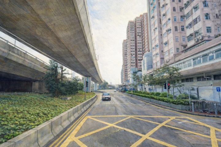
干諾道西位於香港島西區,是一條沿着維多利亞港延伸的重要城市道路,其歷史與香港的填海工程、港口發展以及城市擴展緊密相連。若從今天的城市景觀來看,這條道路車流繁忙,兩旁分佈着商業大廈、住宅與各類店舖,呈現出典型的香港都市面貌。然而在十九世紀中葉,這裡仍然是海岸線的一部分,海水拍打着山腳,城市尚未向北擴展。香港在1841年開埠後,最初的城市發展集中於中環與上環一帶,隨着港口貿易迅速增長,人口與商業活動不斷增加,有限的土地開始不足以應付需求,因此殖民政府逐步推行填海工程,以擴展城市空間。干諾道正是在這樣的歷史背景下誕生,其名稱來自英國皇室人物干諾公爵,反映殖民時期以皇室與貴族命名街道的傳統。隨着城市不斷向西與向北延伸,干諾道被劃分為干諾道中與干諾道西,而後者主要連接上環與西區各個社區。到了十九世紀末至二十世紀初,維多利亞港已成為亞洲最繁忙的港口之一,大量商船在此停泊,貨物經由香港轉運至世界各地,干諾道西因鄰近碼頭與倉庫區而逐漸發展為港口經濟的重要通道。沿街出現倉庫、商舖與辦公樓,形成一種典型的海港城市街道景觀。從交通角度來看,干諾道西是港島西區重要的東西向幹道,連接上環、西營盤與堅尼地城,使不同社區之間保持高效聯繫。電車軌道沿着道路鋪設,自1904年香港電車投入服務以來,電車一直沿着港島北岸行駛,而干諾道西正是其中的重要路段之一。電車在街道中央緩慢前行,與周圍快速流動的車輛形成對比,成為香港獨特的城市景觀。隨着二十世紀多次填海工程的推進,海岸線逐漸向北移動,原本臨海的干諾道西逐漸轉變為內陸道路,而新的海旁道路與建築則在更北面出現。儘管地理位置發生變化,干諾道西仍然保持其交通與商業功能,並持續服務西區居民與商業活動。從城市景觀角度來看,這條道路呈現出新舊交錯的特點,一方面有現代高樓與辦公大廈,另一方面仍保留部分舊式建築與傳統店舖,使街道具有明顯的歷史層次。從文化層面來看,干諾道西同樣反映香港的中西交融特質,街道名稱源自英國皇室,而街道上的日常生活則由本地居民與商戶所構成,這種文化並置使香港城市具有獨特的身份。今天走在干諾道西,可以看到電車、巴士與各類車輛交織運行,人們在街道上穿行,商業與生活並存。這條道路不僅是一條交通幹線,更是一段城市歷史的延續,從十九世紀的海岸線,到今日的城市內陸幹道,干諾道西見證了香港不斷向海擴展與自我重塑的過程。
English Version
Connaught Road West, located along the western section of Hong Kong Island’s northern corridor, represents a crucial layer in the city’s historical and spatial evolution, a road whose existence is inseparable from the processes of land reclamation, maritime trade, and urban expansion that have defined Hong Kong since its early colonial period, and while today it appears as a busy urban artery lined with commercial buildings, residential blocks, and a continuous flow of traffic, its origins lie in what was once the shoreline of Victoria Harbour, where waves once met the base of the hills before the city gradually extended outward through engineering and development; following the establishment of Hong Kong as a British colony in 1841, early urban growth was concentrated in Central and Sheung Wan, where administrative and commercial activities were anchored, but as trade intensified and the population increased, the demand for land led to systematic reclamation projects along the northern coast, creating new terrain upon which roads and buildings could be constructed, and it was within this context that Connaught Road emerged, later divided into sections including Connaught Road West, with its name derived from the Duke of Connaught, reflecting the colonial tradition of embedding imperial identity within the urban landscape; as the nineteenth century transitioned into the twentieth, Victoria Harbour became one of the busiest ports in Asia, facilitating global trade and reinforcing Hong Kong’s position as a key transshipment hub, and Connaught Road West, situated close to piers and warehouse districts, naturally developed into a vital route supporting port-related economic activity, with warehouses, offices, and shops lining the street and contributing to a dynamic and functional urban environment; from a transportation perspective, the road plays a significant role in connecting western districts such as Sheung Wan, Sai Ying Pun, and Kennedy Town, enabling efficient east–west movement across the island, and it is also an integral part of the Hong Kong Tramways network, which has operated since 1904, with tram tracks running along the corridor and adding a distinctive visual and cultural element to the street, where the slow movement of trams contrasts with the faster pace of modern vehicles, creating a layered experience of time and motion within the city; over the course of the twentieth century, continued reclamation projects pushed the coastline further north, gradually transforming Connaught Road West from a waterfront edge into an inland urban route, while new roads and developments emerged closer to the harbor, yet despite these geographical shifts, the road has retained its importance as both a transport corridor and a site of commercial activity, demonstrating the resilience of urban infrastructure even as the physical environment evolves; architecturally, the street presents a mixture of old and new, where modern high-rise buildings stand alongside older structures that hint at earlier phases of development, creating a textured cityscape that reflects continuity and change simultaneously; culturally, Connaught Road West embodies the dual identity of Hong Kong, where its English name points to colonial history while the everyday life unfolding along the street is shaped by local residents, businesses, and traditions, illustrating how historical frameworks are integrated into contemporary urban experience; throughout the day, the road is animated by vehicles, pedestrians, and commercial exchanges, while at night it transforms into a quieter yet still active corridor illuminated by streetlights and building facades, maintaining a sense of continuity within the city’s rhythm; ultimately, Connaught Road West is more than a physical roadway, it is a narrative of transformation, tracing Hong Kong’s journey from a coastal trading post to a densely built metropolis, and in traveling along it, one moves not only through space but also through the layered history of a city defined by adaptation, expansion, and constant reinvention.